Our Snowpack this Year is Really Low. Historically low.

Zone Code Update Comment Guide
February 9, 2024
We’re in a Drought. What can we do about it?
March 1, 2024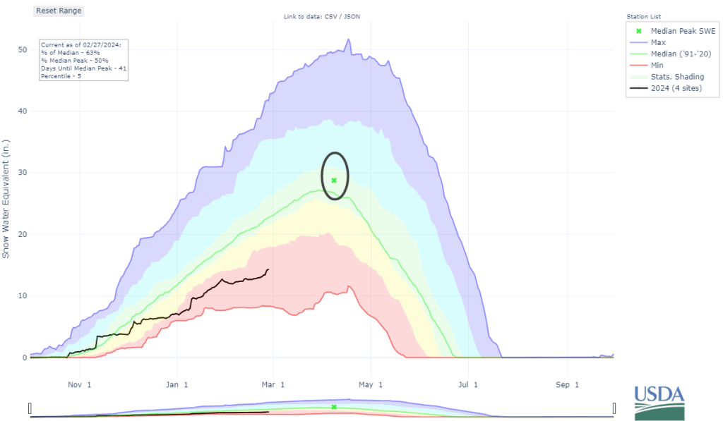
This mountain-shaped graph below represents the water stored in the Methow watershed’s snowpack.This year, it’s really low. |
 |
That circled x is where we want to get to. The black line is where we are. We’re not going to make it there.Even a big March won’t land us close. At the end of February we have the snow water equivalent (SWE)—the inches of water present in the snowpack—that we’d usually see in early January. We’re hovering in the mid-60th percentile of SWE. And we’ve hardly had any low elevation snow which replenishes our aquifers and our wells.It gets a bit more concerning when we look at this graph: |
 |
Yikes! Stacked bar graphs!Each bar is a year’s worth of snowmelt. The timeline stretches back to 1984. Each color is a month’s worth of stored water (in snowpack).In the last 40 years we’ve only had two years(!) with this little stored water at this point (2005 and 2001)We live in a semi-arid valley that is highly dependent on mountain snowpack to sustain our river and aquifers that provide water to us all. We know the mountain snowpack is diminishing and our precipitation patterns are changing as a result of climate change. Look back at that bar graph! The height of the bars is trending downwards. (if you’re not into graphs, local climate scientist Amy Snover does a great job of explaining why a decreasing mountain snowpack affects us all in this Living River video) *Both graphs are from NRCS’s very neat interactive mapping tool which you can check out here. |
